• Galleries
  • Blog
  • About
Menu

Paul Stachelek - Photographs

  • Galleries
  • Blog
  • About

pstachelek@gmail.com

(Click on image to see entire gallery)

Notions

Notion: “a vague or imperfect conception or idea of something”

Most of these images are scans from early work in color slide film (mostly San Diego and many downtown before redevelopment).

Tire_flt_AHDR_S.jpg
BoraxWall 5.jpg
BoraxWall2.jpg
15.6x30BoraxWall.jpg
BoraxWall3.jpg
MexWallCircles.jpg
MexChairWall.jpg
MexWallConvergingLines.jpg
As Is_flt_AHDR_S.jpg
Pepsi Wall-sharpen-sharpen.jpg
Wall_bricks_flt_AHDR_S.jpg
No Parking.jpg
Starting Time.jpg
RedTrainSwitchHorz2-Edit-sharpen-sharpen.jpg
Yellow Billboard-sharpen-sharpen-2.jpg
CocaCola-2-sharpen-sharpen-sharpen-sharpen.jpg
Red Paint.jpg
BoraxWall1.jpg
BoraxWall4.jpg
Double Vision_2.jpg
MexWallYellowA.jpg

Iterations

Myakka River, FL, 2023.jpg
Palms, Myakka State Park, FL, 2023.jpg
French Broad River, Asheville, NC, 2019,(2024).jpg
The Moat, Sarasota, FL 2022.jpg
Near Giljaland, Iceland 2017:2024.jpg
Gound View, FL, 2015.jpg
Torrent, FL, 2015.jpg
PalmIslandPark_oak.jpg
PalmIslandPark_swamp.jpg
PalmIslandBentOak.jpg
IMG_3205.JPG
Prescribed Burn, Yosemite, CA, 2005-2024.jpg
Grow Strong Regardless, Yosemite, CA, 2003-2024.jpg
Philodendron, Winter, FL 2015.jpg
PuffBalls_GA.jpg
Asheville, NC, 2019.jpg
Seneca Falls, NY, 2019.jpg
Savannah-4431_AuroraHDR2019-edit.jpg

Modern Pictorialism

Fishing Spot2.jpg
French Broad River.jpg
Philo ground.jpg
Hofn grass.jpg
Rocks North Boquet.jpg
Island rock Pt Lobos.jpg
Jokulsarlon_.jpg
Oak_Jessup Park_FL_2019.jpg
Prescribed Burn, Yosemite, CA, 2005-2024.jpg
Squash.jpg
St. Johns_Savannah_2018.jpg
Anza Borrego, Black Rock, c 2014.jpg
Storage Tanks.jpg
Beach, Jekyll Island, GA, 2024.jpg
Cypress Gardens, FL 2019.jpg
CypressKnees.jpg
Driftwood Beach1, Jekyll Island, GA 2024.jpg
DriftwoodBeach2.jpg
GA pond trees.jpg
Grassland, Yosemite, CA, 2002.jpg
KiwaneeTrailFF.jpg
Sequoia trunk picto.jpg
Trimble Park, Florida2, 2025.jpg
Trimble Park2, FL 2025.jpg
YosemiteGlacierPine.jpg

Iceland

Called “the land of fire and ice”, Iceland is characterized by its geographic landmarks including volcanoes, glaciers, geysers, waterfalls, tectonic rifts, molten lava fields and treeless grasslands.

The terrain of Iceland is diverse. It can be verdant and serene and it can be rugged, harsh and sometimes violent…but in most cases it is visually stunning.

All photographs made in June 2017.

Reynisdrangar_6x9.jpg
Seljalandsa.jpg
Near AsolfsskalakirkaC.jpg
ThorvaldseyriC.jpg
AsolfsskalakirkaC.jpg
Asolfsskalakirka ViewC.jpg
Skoga River.jpg
Skogafoss.jpg
Dyrholaey.jpg
Arnardrangur.jpg
Mooring at Dyrholaey
Halsanefshellir.jpg
Reynisfjara.jpg
Reynisfjall detail.jpg
Columnar Basalt.jpg
Jokulsarlon.jpg
Evening HofnC.jpg
Hofn, eddy.jpg
SF173-Hofn Port.jpg
Hofn, (S)F-52.jpg
Hofn, Akurey_600x900.jpg
Almannagja Overlook.jpg
Thingvallavatn Lake and Rifts.jpg
Almannagja.jpg
Oxararfoss.jpg
Oxara.jpg
Stone Fence.jpg
Homestead1.jpg
Homestead2.jpg
Althingishusio.jpg
Domkirkjan.jpg
Hallgrimskirkja.jpg
Door_Reykjavik.jpg
Arnarneshaed homes.jpg
Bureaucrat.jpg
Reykjavik Harbor.jpg

Anna Maria Island, FL

Anna Maria Island is a seven-mile long barrier island on Florida’s Gulf Coast the main attraction being the turquoise waters and white sandy beaches. Originally used for hunting and fishing by various Native American tribes, the only way on and off the island was by boat. In 1892, George Emerson Bean became the first permanent resident on the island followed by John Roser. These two men and their families developed the area by adding streets, a water system and homes. Today, tourism development has been targeted as a key economic goal.

AnnaMariaIsland-3_AuroraHDR2018-edit.jpg
AnnaMariaIsland-60_AuroraHDR2018-edit.jpg
AnnaMariaIsland-58_AuroraHDR2018-edit.jpg
AnnaMariaIsland-9_AuroraHDR2018-edit.jpg
AnnaMariaIsland-13_AuroraHDR2018-edit.jpg
AnnaMariaIsland-16_N+2_AuroraHDR2018-edit.jpg
AnnaMariaIsland-19_AuroraHDR2018-edit.jpg
AnnaMariaIsland-24_AuroraHDR2018-edit.jpg
AnnaMariaIsland-53_AuroraHDR2018-edit.jpg
AnnaMariaIsland-55_editv1_AuroraHDR2018-edit.jpg
AnnaMariaIsland-59_AuroraHDR2018-edit.jpg
AnnaMariaIsland-63_AuroraHDR2018-edit.jpg
AnnaMariaIsland-34_AuroraHDR2018-edit.jpg
AnnaMariaIsland-51_AuroraHDR2018-edit.jpg
AnnaMariaIsland-52_AuroraHDR2018-edit.jpg
AnnaMariaIsland-50_AuroraHDR2018-edit.jpg
DSCF0436_AuroraHDR2018-edit.jpg
AnnaMariaIsland-121_AuroraHDR2018-edit.jpg
DSC_1510_AuroraHDR2018-edit.jpg
DSC_1543_lay.jpg
DSC_1548_AuroraHDR2018-edit.jpg
DSC_1565_AuroraHDR2018-edit.jpg
DSC_1573_AuroraHDR2018-edit.jpg
DSC_1593_AuroraHDR2018-edit_0.jpg
DSC_2001_AuroraHDR2018-edit.jpg
DSC_2002_AuroraHDR2018-edit.jpg
_DSC3814.jpg
_DSC3822_AuroraHDR2018-edit_0-Edit.jpg
_DSC3828_AuroraHDR2018-edit.jpg
_DSC3833_AuroraHDR2018-edit.jpg
_DSC3841_AuroraHDR2018-edit-Edit.jpg
_DSC3864_tonemapped.jpg

Blue Ridge, GA

The Blue Ridge Mountains form the eastern front of the Appalachian Mountains running from Pennsylvania in the north to Georgia in the south. When thy reach Georgia in the northeastern part of the state, the mountains turn westward and expand up to sixty miles in width.

The Blue Ridge Mountains are noted for having a bluish cast when seen from a distance. Primarily this cast is created by the properties of light, organic compounds given off by plants (especially pines in the region), and perception.

This photographic essay demonstrates landscape photographs made in and around Blue Ridge, GA in the fall of 2014. Additional photos included are from Blairsville, GA, Murphy, NC, Brasstown, NC and Amicalola Falls State Park in Dawsonville, GA.

DSC_2228.jpg
DSC_2155.jpg
DSC_2166.jpg
DSC_2048.jpg
DSC_2060.jpg
DSC_2088.jpg
DSC_2154.jpg
DSC_2098.jpg
DSC_2101.jpg
DSC_2195.jpg
DSC_2248.jpg
DSC_2212.jpg
DSC_2211.jpg
DSC_2214.jpg
DSC_2237.jpg
DSC_2226.jpg
DSC_2229.jpg
DSC_2170.jpg
DSC_2171.jpg
DSC_2173.jpg
DSC_2176.jpg
DSC_2179.jpg
DSC_2186.jpg

Yosemite, CA

“The far-famed valley came suddenly into view throughout almost its whole extent: the noble walls, sculptured into endless variety of domes and gables, spires and battlements and plain mural precipices, all a-tremble with the thunder tones of the falling water. The level bottom seemed to be dressed like a garden, sunny meadows here and there and groves of pine and oak, the river of Mercy sweeping in majesty through the midst of them and flashing back the sunbeams.” —John Muir

Most of these photographs were made between 2002-04. This was a particularly dry period and forecast a significant drought in California between 2007-09. What are conspicuously absent are photographs representing the “thunder tones of falling water” during this period. Many waterfalls ran dry or only at a trickle.

For further inquiries about books, prints and limited edition portfolios contact pstachelek@gmail.com

3237_Tunnel View.jpg
3255_RT16_Merced Morning.jpg
3259_RT16.jpg
3277_RT16-Edit-2.jpg
3280_RT16-Edit.jpg
3282_RT16.jpg
3290_RT16.jpg
3319_RT16.jpg
3333_RT16.jpg
3367_RT16.jpg
3406_RT16_HDR.jpg
3374_RT16.jpg
3401_RT16.jpg
CRW_5322_RT16.jpg
CRW_5362_RT16.jpg
CRW_5370_RT16-Edit-2.jpg
CRW_5382_RT16-Edit.jpg
CRW_5388_RT16-Edit.jpg
CRW_5394_RT16-Edit.jpg
CRW_5411_RT16-Edit.jpg
CRW_5412_RT16-Edit.jpg
CRW_5431_RT16-Edit.jpg
IMG_8771-Edit.jpg
IMG_8804-Edit.jpg
IMG_8814-Edit.jpg
IMG_8900.jpg

Point Lobos, CA

Point Lobos State Natural Reserve is located near Carmel-By-The-Sea in California. Point Lobos is often considered the “crown jewel” of the California State Park system. Nature lovers (and photographers) have long spent time exploring and admiring this delicate ecosystem where the Pacific Ocean meets the coast.

IMG_1428.jpg
IMG_1466.jpg
IMG_1424.jpg
IMG_1410.jpg
PtLobos_rock thru trees.jpg
IMG_1454.jpg
IMG_1432.jpg
IMG_1473.jpg
IMG_1477_HDR.jpg
IMG_1412.jpg
IMG_1475.jpg
IMG_1467.jpg
IMG_1479.jpg
IMG_1462.jpg
IMG_1480.jpg
IMG_1420.jpg

Bodie, CA

Bodie, CA is an original gold mining town from the late 1800s. In 1859 William S. Bodey discovered gold near what is now called Bodie Bluff (change of spelling). A mill was established in 1861 and the town began to grow. It started with about 20 miners and grew to an estimated 10,000 people by 1880. What’s left today stands in a state of “arrested decay”. Bodie is maintained by the California State Parks system, which took over the town in 1962 and made it a State Historic Park.

3575_RT16-Edit.jpg
3534_RT16-Edit.jpg
3545_RT16-Edit.jpg
3579_RT16.jpg
3584_RT16.jpg
3588_RT16.jpg
3527_RT16-Edit-Edit-2.jpg
3539_RT16-Edit-2.jpg
3540_RT16.jpg
3541_RT16.jpg
3544_RT16.jpg

Antique Gas and Steam Engine Museum

The Antique Gas and Steam Engine Museum in Vista, CA is the setting for this visual exploration of the colors, shapes, and textures distinguished by various examples of mechanical ingenuity and crafts associated with the early days of the American farm and rural community.

IMG_0959.jpg
_MG_0515.jpg
IMG_0964.jpg
_MG_0544.jpg
IMG_0992.jpg
IMG_1003.jpg
IMG_0996.jpg
AGSEM 9-08-18.jpg
IMG_0223.jpg
_MG_0543.jpg
_MG_0629.jpg
AGSEM 9-08-6.jpg
AGSEM 9-08-9.jpg
AGSEM lead.jpg
IMG_1000.jpg
IMG_0203-Edit2.jpg
IMG_0967.jpg
_MG_0605.jpg
IMG_1006.jpg
_MG_0552.jpg
_MG_0559.jpg
IMG_0916.jpg
_MG_0553.jpg
_MG_0562.jpg
_MG_0589.jpg
IMG_0913.jpg
_MG_0614.jpg
_MG_0572.jpg
_MG_0584.jpg
_MG_0613.jpg
_MG_0548-Edit.jpg
_MG_0564.jpg
IMG_0990.jpg
_MG_0625.jpg
AGSEM_9-20_0005.jpg
_MG_0603.jpg
_MG_4876.jpg
AGSEM 9-08-10.jpg
IMG_0926.jpg
AGSEM 9-08-25.jpg
IMG_0985.jpg
AGSEM 9-08-43.jpg
AGSEM 9-08-38.jpg
AGSEM 9-08-42.jpg
AGSEM 9-08-39.jpg
AGSEM 9-08-45.jpg
IMG_0909.jpg
_MG_0533.jpg
IMG_1004.jpg
IMG_0195.jpg
IMG_0941.jpg
IMG_0972.jpg

Devil's Den, Gettysburg, PA

Devil’s Den is a boulder strewn area located in the Gettysburg National Military Park near Gettysburg, Pennsylvania. The original name is somewhat uncertain, but local lore tells of a large snake that inhabited the area and acquired the name, “The Devil”. The boulders were presumed to be the snake’s den; thus, “Devil’s Den”.

On the second day of the Battle of Gettysburg, Confederate soldiers occupied Devil’s Den which provided their sharpshooters with an excellent vantage point to fire on Union positions held on a hill named Little Round Top.

The next to the last photo in this sequence is a familiar location to those familiar with the history of photography. It was here that Civil War photographer Alexander Gardner staged a photograph by dragging a dead Confederate soldier into this location and propping him against the boulders.

_DSC3677-Edit_lay-Edit.jpg
_DSC3687-Edit-3.jpg
_DSC3678-Edit.jpg
_DSC3679.jpg
_DSC3686_AuroraHDR2018-edit-Edit.jpg
_DSC3690_AuroraHDR2018-edit_0-Edit.jpg
_DSC3667-Edit_lay.jpg

People

Sushi Gallery.jpg
DG Wells.jpg
David Avalos.jpg
Birdie Carter.jpg
Brothers in Art.jpg
Bob Carr Rowing_1989.jpg
Beth Knight_roughwater017.jpg
Aerosol Artist.jpg
Carney.jpg
Cohuilla Girl014-Edit.jpg
Cohuilla Vendor015.jpg
El Jefe.jpg
Imperial Valley ride.jpg
Don Zub018.jpg
Francis Ryan020.jpg
Elizabeth Leech DVM011.jpg
Industrial Painter.jpg
Kingsley McClaron.jpg
KenTaylor_rock.jpg
Lynn Eldred.jpg
Speedy Ruiz008.jpg
Kick Boxer013.jpg
Sunny Sweed_Funland019.jpg
Weight Lifter012.jpg
Swig.jpg
Couple at Concert I031.jpg
Couple at Concert II_032.jpg
SeriousGirls at Concert034.jpg
Two Girls at Concert033.jpg
Garage Band_1989023.jpg
Dickhead_1989.jpg
Couple in Kitchen028.jpg
Naturalization_1989_024.jpg
Cynthia Reeves Snow027.jpg
Demonic Band Pair030.jpg
Pablo Leon025.jpg
Concert Montage_flt.jpg

Snowbirds

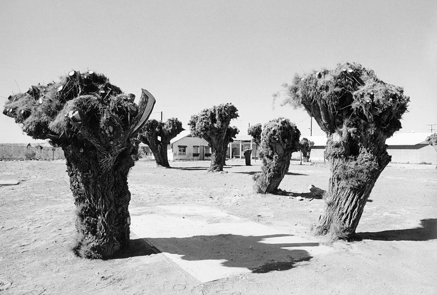
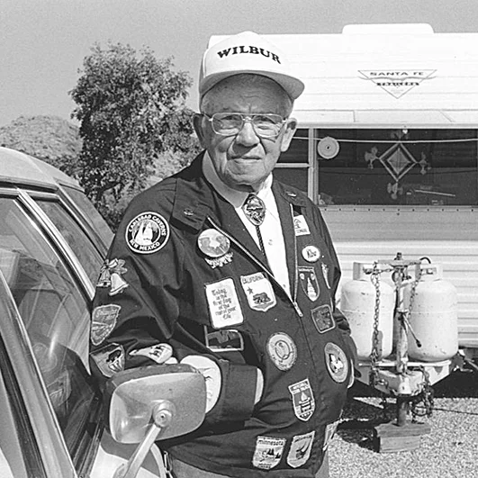
Around 1984 I developed an interest in the semi-nomadic lifestyle of older/retired Americans who traveled to the southwestern deserts for wintering. Commonly referred to as, “snowbirds”, there are basically three migratory paths followed during the winter in the US; east, mid-west and west. My focus was the west in the southern California and Arizona deserts.

Most snowbirds return to their northern homes, typically just before April 15th (to send in their federal income tax returns!). However, some had become “full-timers” meaning they lived year round in their RV’s and migrated around the country based on seasonal changes. They had sold their brick and mortar homes of 30 or 40 years for the nomadic lifestyle.

There are also many choices to “land” with this lifestyle. Some might choose a planned RV community around Yuma, AZ for example, where the RV is placed on a concrete pad and hook-ups of gas and electric and various amenities can be acquired. Others stay on BLM (Bureau of Land Management) where, at the time, they applied for 14-day permits. After 14-days, they would have to move to another BLM location. This is somewhat of a more primitive, camping lifestyle. But, each RV’s had a supply of water, toilet, cooking, refrigeration, heating/cooling and various accoutrements.


The socio-economic structure to these encampments tended to be homogenous, but not entirely. It was very possible that a $300,000 BlueBird RV could be found camped on BLM land with a pick-up and camper shell. What did appear to be a common thread amongst the snowbirds is that they were from relatively the same generation and shared common life experiences. They had all grown up someplace, gone to school, gotten married, worked a job, had children and now found themselves in a new phase of life. It didn’t seem to matter what the details of all those years were, but the fact that you made it through and now you found yourself “here”, in the middle of the desert.

Max_Lydia.jpg
CoffeeCanMan.jpg
Nice Couple.jpg
Breakfast.jpg
Desert Jam.jpg
Group Portrait.jpg
Sitting Around.jpg
Fish Story.jpg
Jewelry Maker.jpg
Just like home.jpg
Windsock man.jpg
Smiley man_Winnebago.jpg
Men Dancing.jpg
Black Velvet.jpg
Lake Havasu.jpg
Colorado Bell.jpg
Capt Claude.jpg
BLM Volunteer.jpg
Bounty.jpg
Keep Out man.jpg
Man Smoking.jpg
Pealing Apple.jpg
Old Stove.jpg
Truck Maintenance.jpg
River Rock design.jpg
Lone RV.jpg
YumaPark_palms.jpg
Falling Parts.jpg
Dodge Capricorn.jpg
Brave At Lake Martinez.jpg
Gulls.jpg
NewPark_fence.jpg
Rock Garden.jpg
Utilities.jpg
Dry Camp $4.jpg
Clothes Line.jpg
Undergarments.jpg
Interior Desert View.jpg
Mailboxes.jpg
Tower.jpg
TruckCamper_man.jpg
Mexican Medicine.jpg
Dentista.jpg
Pad and Trees.jpg

Assemble

Among the rights attributed to Amendment I of the US Constitution is “the right of the people peaceably to assemble, and to petition the Government for a redress of grievances”.

Jose Napoleon Duarte led a civil-military Junta from 1980 to 1982 and was then elected president of El Salvador in 1984. Supported by the Reagan Administration and the CIA, his time in office occurred during the worst years of the Salvadoran Civil War which saw numerous abuses and massacres of the civilian population by the Salvadoran security forces and the death squads linked to them. When Ronald Reagan became President of the US, Duarte became a symbol for “anti-communism” although documents later showed that far more human rights violations were carried out by the Junta than the FMLA anti-government guerillas.

These photographs depict demonstrations staged against US support for the Duarte Junta. Photographs were made in 1983-1984 in Tijuana, San Diego, Los Angeles and the project culminated in San Francisco at the time of the Democratic Convention held there.

Photographing these events was a visual exercise in both photojournalism and street photography. I was impressed with the guerrilla theater that accompanied these assemblies. Elaborate costumes, make-up, props and performances punctuated the message. Signs, chants, music, and puppets accompanied the hundreds of participants that filled the street.

Assemble010.jpg
Assemble018.jpg
Assemble019.jpg
Assemble007.jpg
Assemble012.jpg
Assemble024.jpg
Assemble006.jpg
Assemble001.jpg
_DSC5396-sharpen-sharpen.jpg
Assemble004.jpg
Assemble039.jpg
Assemble005.jpg
Assemble013.jpg
Assemble014.jpg
Assemble067.jpg
_DSC5394-sharpen-sharpen.jpg
Assemble087.jpg
Assemble011.jpg
Assemble015.jpg
Assemble020.jpg
Assemble021.jpg
Assemble037.jpg
Assemble034.jpg
Assemble076.jpg
Assemble049.jpg
Assemble022.jpg
Assemble051.jpg
Assemble046.jpg
Assemble055.jpg
Assemble043.jpg
Assemble045.jpg
Assemble003.jpg
Assemble053.jpg
Assemble069.jpg
Assemble023.jpg
Assemble025.jpg
Assemble026.jpg
Assemble027.jpg
Assemble028.jpg
Assemble060.jpg
Assemble056.jpg
Assemble032.jpg
Assemble033.jpg
Assemble029.jpg
Assemble030.jpg
Assemble062.jpg
Assemble036.jpg
Assemble080.jpg
Assemble047.jpg
_DSC5390-sharpen-sharpen.jpg
Assemble061.jpg
Assemble065.jpg
Assemble061.jpg
Assemble082.jpg
Assemble088.jpg
Assemble077.jpg
Assemble079.jpg
Assemble070.jpg
Assemble081.jpg
Assemble083.jpg
Assemble085.jpg

Monochromes

Tufa, Mono Lake, CA, 2002.jpg
Reynisdrangar, Iceland, 2017.jpg
Cole Lake, Ontario, Canada, 2017.jpg
County Park, Blue Ridge, GA, 2014.jpg
Cypresss, Lake Eloise, FL 2019.jpg
Slyder Farm, Gettysburg, PA, 2017.jpg
French Broad River, Asheville, NC, 2019.jpg
Palm Canyon, Anza-Borrego State Park, CA, 2009.jpg
Chokecherry, Bloomfield, NY, 2017.jpg
Bryce Canyon National Park, UT, 1987.jpg
Anna Maria Island, FL, 2013.jpg
Palms, Anna Maria Island, FL, 2013.jpg
North Fork Boquet River, NY, 2010.jpg
Puffballs, Blue Ridge, GA, 2014.jpg

Savannah, GA - 2018

This was a cursory overview of the historic Savannah Riverfront district done in the summer of 2018. At the time, the heat index was around 106 degrees. Needless to say, we did not stay long. We joked about going to where it was cooler; in Florida!!! Some of the images are made handheld at night (when it was cooler). I like the use of monochromatic images for these architectural subjects; seemed to fit the period. Lovely place; full of history, southern hospitality and cuisine.

Savannah-4401-Edit-Edit.jpg
Savannah-4380-Edit-Edit.jpg
Savannah-4368-Edit.jpg
Savannah-4382-Edit.jpg
Savannah-4366-Edit-4-Edit.jpg
Savannah-4397-Edit.jpg
Savannah-4409-Edit.jpg
Savannah-4399-Edit.jpg
Savannah-4374-Edit.jpg
Savannah-4375-Edit.jpg
Savannah-4431-Edit.jpg
Savannah-4373-Edit.jpg
Savannah-4363-Edit-2.jpg
Savannah-4426-Edit-Edit.jpg
Savannah-4376-Edit-Edit.jpg
Savannah-4378-Edit.jpg
Savannah-4389-Edit.jpg
Savannah-4398-Edit.jpg
Savannah-4418_edit1-Edit.jpg

Mexico (1983)

Black and white photographs taken on a trip to Mexico during December 1982 and January 1983. Locations include; Mexico City, Oaxaca, Puebla, Mazatlan, Yelapa, Puerto Vallarta. Original 35mm black and white negatives digitally photo copied.

Mitla.jpg
Fish.jpg
3 boats.jpg
One Boat.jpg
_DSC2358-Edit.jpg
Pier.jpg
Girl on Pier.jpg
_DSC2360-Edit.jpg
_DSC2365-Edit.jpg
Hotel Nido, Chapala, 1983.jpg
Coconuts.jpg
Naranca, Mexico City, 1982.jpg
Silo.jpg
La Playa, Chapala, 1983.jpg
Beach at Yalapa.jpg
Boy from Yalapa.jpg
Dusk_MonteAlban.jpg
Museo.jpg
Monte Alban.jpg
doorway_ruins.jpg
DoubleDoor.jpg
LockDoor.jpg
RoundCorner.jpg
Vendor_Medias.jpg
_DSC2302-Edit.jpg
Xochi_Market1.jpg
Xochi_Mother and child.jpg
Xochi_Woman with Corn.jpg
XochiMarket_ManHat.jpg
Xochi_woman weighing.jpg
Young Vendor.jpg
LaMichoacana.jpg
_DSC2389-Edit.jpg
Chapultepec overview.jpg
Canons.jpg
fountain.jpg
11-11 mirror.jpg
Around the Fountain.jpg
Las Senoritas.jpg
Centro Reflection.jpg
GuardRail.jpg
museum interior.jpg
Building?.jpg
ModernBldg.jpg
Big Pinata.jpg
Church Interior.jpg
Miguel Serrano.jpg
TheGuideMitla.jpg
_DSC2383-Edit.jpg
FourMenandBicycle.jpg
CowSkull.jpg
Tomatoes.jpg
Poster.jpg

More Mexico

Mex 1987.jpg
Mex 1987-2.jpg
Mex 1987-3.jpg
Mex 1987-4.jpg
Mex 1987-5.jpg
Mex 1987-6.jpg
Mex 1987-7.jpg
Mex 1987-8.jpg
Mex 1987-9.jpg
Mex 1987-10.jpg
Mex 1987-11.jpg
Mex 1987-12.jpg
Mex 1987-13.jpg
Mex 1987-14.jpg
Mex 1987-15.jpg
Mex 1987-16.jpg
prev / next
Back to Paul Stachelek - Photographs
21
Notions
18
Iterations
25
Modern Pictorialism
Reynisdrangar.jpg
36
Iceland
32
Anna Maria Island, FL
23
Blue Ridge, GA
3237_Tunnel View.jpg
26
Yosemite, CA
16
Point Lobos, CA
3575_RT16-Edit.jpg
11
Bodie, CA
IMG_0959.jpg
52
Antique Gas and Steam Engine Museum
_DSC3677-Edit_lay-Edit.jpg
7
Devil's Den, Gettysburg, PA
Dickhead_1989.jpg
37
People
44
Snowbirds
61
Assemble
14
Monochromes
19
Savannah, GA
53
Mexico (1983)
17
More Mexico

Powered by Squarespace